- A Charles Sturt University research project in Indonesia aims to overcome the information gap about the impact of river barriers on ecosystems and biodiversity
- The project with the UN Food and Agriculture Organisation (FAO) and the Indonesian Government is funded by the Australian Water Partnership (AWP)
- The project will enable national policy makers and technical officers to appropriately identify and remediate river connectivity issues
A Charles Sturt University and United Nations Food and Agriculture Organisation (FAO) project is assisting the Government of Indonesia to bridge the information gap about the impact of river barriers on ecosystems and biodiversity.
The project was funded by the Australian Water Partnership (AWP) through the Australian Government’s Department of Foreign Affairs and Trade (DFAT).
Project coordinator and Senior Lecturer in Geospatial Science Dr Ana Horta (pictured, inset) in the Charles Sturt School of Agricultural, Environmental and Veterinary Sciences and researcher in the Charles Sturt Gulbali Research Institute of Agriculture, Water and Environment said this information gap limits authorities’ ability to appropriately identify and remediate river connectivity issues.
“River basin infrastructure in Indonesia has been rapidly increasing over the past 20 years,” Dr Horta said.
“This has been to cater for expanding agriculture, rising energy demand, and flood protection with the development of dams, hydroelectric plants, levees, canal systems, tidal barrages, sluices, flood control structures, and bridges.
“While these projects bring immediate socio-economic advantages, they also unfortunately compromise river connectivity, impacting biodiversity and ecosystem services over the longer term.”
 Dr Horta said infrastructure developments that fragment river basins have profound consequences for ecosystems, biodiversity, water resources and local communities.
“One of the primary outcomes is the loss of habitat and biodiversity, as natural habitats are destroyed or degraded by infrastructure such as dams, road crossings and irrigation structures,” she said.
“This fragmentation disrupts connectivity between different parts of the river, preventing the movement of species and genetically and negatively impacting fish populations, exchanging migratory species, and other aquatic organisms.
“Moreover, such fragmentation alters vital ecological processes. It disrupts the natural flow patterns of water, sediments, and nutrients, adversely affecting species distribution, nutrient cycling, and ecosystem functionality.”
Dr Horta said these disruptions have cascading effects on the entire food web and ecosystem, and the socioeconomic implications are equally significant.
River-dependent communities that rely on fisheries for food security face reduced fish populations and restricted access to resources. Altered water flows and availability challenge sectors like agriculture, irrigation, and hydropower, leading to economic strain and potential resource conflicts.
“Currently, there is very limited data on river basin fragmentation in Indonesia, with most databases only cataloguing larger barriers such as dams,” Dr Horta said. “While this is common among most south-east Asian countries, this approach neglects the importance of understanding the cumulative impacts smaller barriers have on river connectivity.
“As a result, there is little known about the impact of these barriers on ecosystems and biodiversity, limiting authorities’ ability to appropriately identify and remediate connectivity issues.”
 Dr Horta said to bridge this information gap, national water authorities require comprehensive data on all barrier types, as this enhances the understanding of river basin connectivity and provides policy makers with a comprehensive understanding of the impacts of future infrastructure projects.
To assist the Government of Indonesia to bridge this information gap, Charles Sturt University (Gulbali Institute) has joined forces with the United Nations Food and Agriculture Organization (FAO) to implement the project ‘Capacity development for spatial planning as a key component of water resources management in Indonesia’.
The project team led by Charles Sturt University and the FAO’s programme manager Ms Caroline Turner includes experts from Australian and Indonesian organisations (Australasian Fish Passage Services and BRIN, Indonesia’s National Research and Innovation Agency), collaborating closely with Kementerian PPN/BAPPENAS (Indonesian National Development Planning Ministry, Water Resources and Irrigation).
The project aims to harness spatial planning to assist water authorities to locate existing river basin barriers, and to evaluate the impact each barrier has on river connectivity.
“Through this learning process the project will equip national policy makers and technical officers with the ability to make holistic decisions regarding river connectivity rehabilitation and the placement of future infrastructure developments,” Dr Horta said.
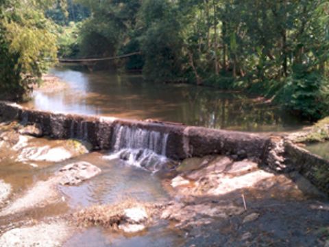
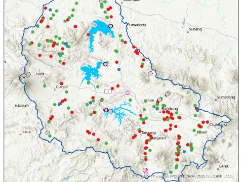
As a case study, the project is carrying out a mapping exercise in the Citarum River Basin. According to public databases there are 15 barriers in the Citarum River Basin, however the project mapping exercise has already identified almost 300 barriers. The map is the first comprehensive river infrastructure map of the Citarum River Basin that includes both larger dams and smaller infrastructure.
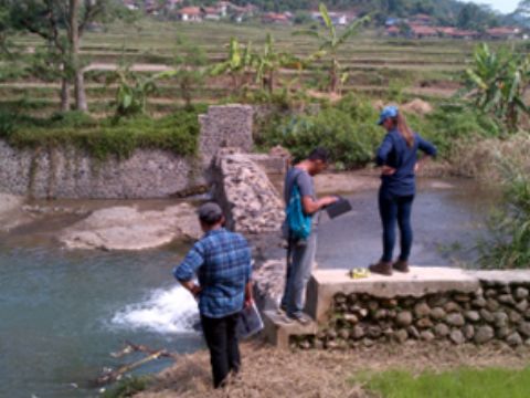
 The project has been working with regional and local stakeholders in water resources management in Indonesia to validate the findings. On-site validation was carried out in July 2023 which served as a training ground for the regional and local water management stakeholders, enhancing their proficiency in leveraging spatial tools to analyse river connectivity.
One of the participants in the field validation, Indah Lestari, from the non-government organisation Yayasan Diversitas Lestari Nusantara (Sustainable Diversity Archipelago Foundation), said the exercise was advantageous to the growth of the expertise of local organisations concerned with all facets of biodiversity.
“I was excited to contribute new knowledge to the community on the topic of spatial mapping for fishways and providing new information on straightforward and precise methods for validating existing barriers in the field,” Indah said.
Once the field validation exercise is complete, and the mapping findings are validated, the project will work with national stakeholders to identify high-risk barriers which pose the greatest impact to river connectivity.
This will be done through the fish barrier prioritisation support system (FBPSS) developed by Mr Tim Marsden through a collaboration between Charles Sturt University and Australasian Fish Passage Services.
“The FBPSS is a low-cost decision support tool designed to identify, assess, and prioritise fish passage barriers for remediation,” Dr Horta said.
“To ensure the sustainability of project outcomes, the project will deliver two capacity building trainings on mapping and the FBPSS approach to enable water management stakeholders to carry out similar assessments on other Indonesian basins in the future.”
The project is due to be completed in March 2024 and will deliver a river connectivity assessment tool to prioritise river infrastructure for rehabilitation according to water use. This resource will be made accessible to water resource managers and local Indonesian conservation groups.


Social
Explore the world of social