Unmanned aerial vehicles are often associated with the military but new research at Charles Sturt University (CSU) shows their increasing importance in civilian life.
Researchers at CSU are examining how the latest remote sensing technology can be used in unmanned aerial vehicles, or UAVs, to ultimately produce a detailed map of weeds invading the Australian rural landscape.
 CSU academic, Dr Remy Dehaan and Professor Leslie Weston, secured a grant of $330 000 from the Federal Government’s Rural Industries Research and Development Corporation (RIRDC) to develop remote sensing technology to apply to the agricultural sector.
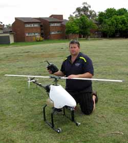
“We have been working on the development of several automated unmanned aerial vehicles including a plane with a 3 metre wing span, a 2 metre long helicopter and several multicopters which will be equipped with sensitive imaging systems to detect weeds and monitor crops in paddocks below,” said Dr Dehaan, a geologist and remote sensing specialist from the School of Environmental Sciences at CSU in Wagga Wagga.
“Once developed, the UAV with hyperspectral remote sensing equipment on board will take to the skies to capture one of the most serious threats to Australia's environment and primary production.
“What we can do with this remote sensing technology is to clearly separate plant materials through their unique spectral signatures. We initially plan to map weeds such as Paterson’s curse and silverleaf nightshade but there are many other agricultural issues that we can use this technology for.”
The research team, including collaborators the universities of Adelaide, New England and Sydney and the University of North Dakota in the USA, has been working with an Australian UAV company, Cyber Technology.
Dr Dehaan embarked on a world-wide search for suitable UAVs, automated guidance system and remote sensing equipment.
A remote control plane was purchased from Bruce Tharpe Engineering in the USA. Known as a BTE Super Hauler, the aircraft was originally designed for the University of North Dakota and has been used by NASA and the US Department of Defense for research activities. Dr Dehaan then purchased the guidance systems from Cyber Technology, who installed and integrated the system into the UAV.
Dr Dehaan said, “One of the novel parts of our research is that it is one of the first hyperspectral remote sensing systems that involves the capture of very detailed images (10 centimetre pixels) from the air. This enables us to look at a smaller area with high detail. We can use this information to separate the different types of weeds.
“This project is exciting; not many universities have access to UAVs and this access is providing opportunites to look at new research.
“We are also using this technology to quantify nitrogen in rice so that we can reduce the amount of fertiliser applied but maintain high yields, and are looking at plant diseases such as stripe rust to see if we can identify it and map its incursion in paddocks. There are numerous areas in agriculture where this technology could be applied.”
It’s hard to imagine few areas in Australia where weeds do not exist. In fact the RIRDC estimates the impacts of weeds on the Australian economy are more than $4 billion per year for control and loss of agricultural productivity.
Professor of Plant Biology and Weed Science Leslie Weston at CSU said, “This technology gives Charles Sturt University unique capacity to study movement of invasive plants over time, particularly in areas that might be difficult to access by traditional methods.
"Over time, we hope to quantify or measure the invasion front, the distance invasive weeds travel in newly infested landscapes. This will provide valuable information when assessing a weed’s capacity to invade new territory and determine if management strategies are effective on a broader scale.
The project has the additional support of the University’s Spatial Data Analysis Network (SPAN). Its Research Support Programmer, Mr Gary McKenzie, helped build the computer which records the pictures in a data acquistion system.


Social
Explore the world of social